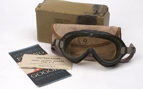
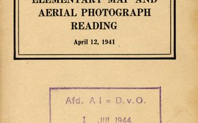
FLYING GOGGLE, Type B-8 bestaand uit stofbril in doos en met mapje waarin drie vensters accompaniment to Mitchell's Reference and distance map of the United States, containing an index of all the counties, districts, townships, towns, etc., in the the … American Revolution, 1775-1783 : an atlas of 18th century maps and charts : theatres of operations / [comp. by W. Bart Greenwood] Symbols for seacoast defense fire-control maps, diagrams, and structures - USA Voorschrift, Technical Regulations, No. Map authorization list : fire control repair parts support for World War II vehicular fleet Usafe Resources management program Elementary map and aerial photograph reading - USA Voorschrift, Basic Field Manual, 21-25 Military map reading / by C.O. Sherrill Elementry map and aerial photography reading - USA Voorschrift, Field Manual Advanced map and aerial photograph reading - USA Voorschrift, Field Manual, 21-26 Advanced map and aerial photograph reading - USA Basic Field Manual, FM 21-26 War 1812 / by George S. May ; maps by Victor H. Hogg ; ill. by Dirk Gringhuis